
Precision Agriculture Technologies
Remote sensing is the technique of acquiring information about an object (plant, soil, etc.) or area from a distance, typically using satellite or aerial sensor technologies. This method involves collecting data without making physical contact with the object being observed. Remote sensing is widely used in various fields such as agriculture, forestry, geology, and environmental monitoring.
Remote sensing enables scientists and farmers to gather valuable data over large areas, providing insights that are crucial for decision-making and management in various domains.
Remote Sensing Technology for the Soil
Soil mapping in precision agriculture involves creating detailed maps that show the different characteristics of soil in a field, such as its type, nutrient levels, moisture content, and pH. By collecting data from various points in the field, farmers can see how these characteristics vary across the land. This information helps them apply the right amount of fertilizer, water, and other inputs where they are needed most, leading to more efficient and productive farming.
Remote soil mapping uses different technologies to gather soil information without needing to physically touch the soil. Here are some methods:
Electromagnetic conductivity: involves measuring how well the soil conducts electricity to gather information about its properties. Special sensors, often mounted on equipment like tractors, send an electromagnetic signal into the soil and measure how much of that signal is returned. The amount of electrical conductivity can reveal details about soil texture, moisture levels, and the presence of salts or nutrients. By analyzing these conductivity measurements, farmers can create maps that show variations in soil conditions across their fields, helping them make more informed decisions about soil management, fertilization, and irrigation.
Gamma-ray sensors: measure natural gamma radiation emitted by the soil to assess its composition. As the sensor moves across the field, it detects gamma rays from radioactive elements like potassium, uranium, and thorium present in the soil. By measuring the intensity of this radiation and collecting soil samples for confirmation, the sensor estimates the concentration of elements, providing data on soil composition such as organic matter and texture (sand, clay, silt, loam). This information is used to create detailed maps showing variations in soil properties across the field, helping farmers make informed decisions about soil management and crop production.
Variable rate applications involve using technology to apply inputs like fertilizers, seeds, or pesticides at different rates across a field based on specific needs (or maps). Instead of applying the same amount everywhere, sensors and maps help determine the right amount for each area, improving efficiency and crop health while reducing waste and environmental impact.
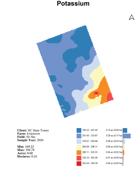
Figure 1. Potassium concentration in soil; map created for the NC State University Horticultural Crops Research Station at Clinton, NC in Spring 2024
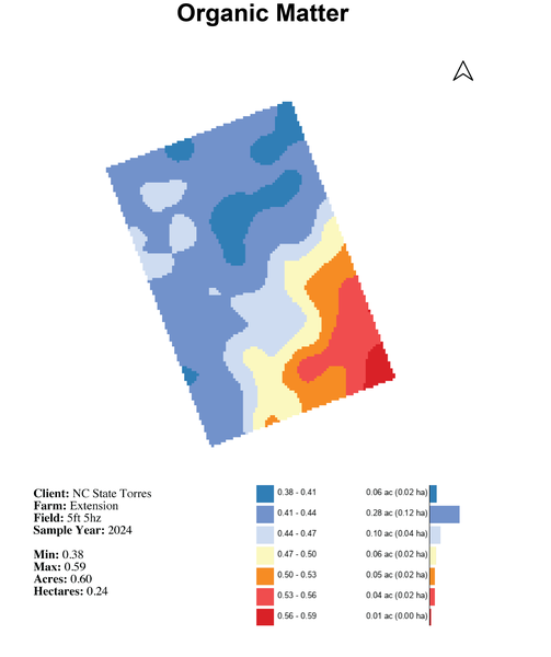
Figure 2. Organic matter concentration in soil; map created for the NC State University Horticultural Crops Research Station at Clinton, NC in Spring 2024
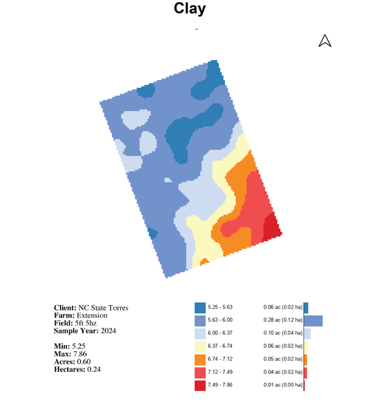
Figure 3. Clay concentration in soil; map created for the NC State University Horticultural Crops Research Station at Clinton, NC in Spring 2024
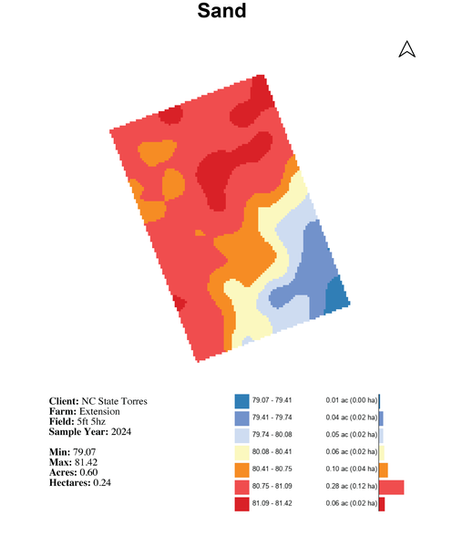
Figure 4. Sand concentration in soil; map created for the NC State University Horticultural Crops Research Station at Clinton, NC in Spring 2024
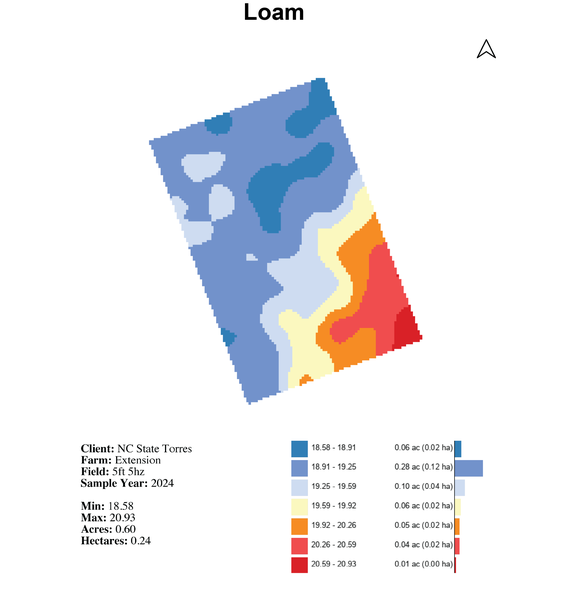
Figure 5. Loam soil distribution; map created for the NC State University Horticultural Crops Research Station at Clinton, NC in Spring 2024
Remote Sensing Technology for the Plant
A multispectral camera is a device used to take pictures of crops in different wavelengths of light, beyond what our eyes can see. These cameras capture images in several specific light bands, such as red, green, blue, and near-infrared. By analyzing these images, farmers can gain detailed information about plant health, growth, and soil conditions, helping them make better decisions about watering, fertilizing, and managing their crops.
Multispectral cameras are different from regular cameras because they capture images in multiple specific wavelengths of light beyond the visible spectrum, such as near-infrared. Regular cameras only capture images in the visible spectrum (red, green, and blue -RGB). This additional information from multispectral cameras allows for detailed analysis of plant health, soil conditions, and other agricultural factors, which regular cameras cannot provide.
A thermal camera is a device that captures images based on heat rather than visible light. It detects infrared radiation emitted by objects and converts it into a visual image where different temperatures are shown in different colors. This allows you to see variations in heat, which is useful for identifying issues such as overheating equipment, detecting heat loss in buildings, or assessing the health of plants and animals. In agriculture, thermal cameras can help monitor irrigation, detect plant stress, and identify pest problems by showing how plants and soil are responding to different conditions.
A vegetation index is a tool used to measure and monitor the health and density of plants in an area using satellite or aerial imagery. It typically involves analyzing the different colors of light reflected by vegetation, especially the red and near-infrared light, to determine how healthy and green the plants are. This helps farmers, scientists, and environmentalists assess plant growth, detect stressed areas, and make informed decisions about land management. Vegetation indices are mathematical formulas calculated using data collected by multispectral and thermal cameras to provide valuable insights into the health and condition of vegetation, helping to identify stress factors, nutrient deficiencies, pest infestations, and diseases early in the growing season.
One of the most used indexes is the Normalized Difference Vegetation Index (NDVI), although there is a large variety of indexes designed for multiple purposes (Table 1). Farmers use NDVI data to monitor the health of their vegetable crops throughout the growing season. Although NDVI doesn’t diagnose the source of the stress, it allows problematic areas to be alerted and human investigation is required to identify potential issues caused by nutrient deficiencies, pest infestations, or water stress. Monitoring NDVI allows for timely interventions, such as adjusting irrigation, optimizing fertilization, or targeting specific areas for pest control.
| Vegetation index | Description |
|---|---|
|
Normalized Difference Vegetation Index (NDVI) |
NDVI is one of the most widely used VIs. It measures the amount of healthy green vegetation in an area by comparing the reflectance of near-infrared (NIR) and red light. NDVI values range from -1 to 1, with higher values indicating healthier vegetation. |
|
Enhanced Vegetation Index (EVI) |
EVI is an improvement upon NDVI that corrects for atmospheric and canopy background influences. It provides a more accurate measure of vegetation cover and health. |
|
Soil Adjusted Vegetation Index (SAVI) |
SAVI is designed to reduce the sensitivity of vegetation indexes to soil brightness. It is useful in areas with exposed soil, where the presence of soil can affect the accuracy of NDVI. |
|
Normalized Difference Water Index (NDWI) |
NDWI is used to detect the presence and condition of water bodies or water stress in vegetation. It compares the reflectance of near-infrared and shortwave infrared (SWIR) bands. |
|
Leaf Area Index (LAI) |
LAI is an index that quantifies the amount of leaf material in a canopy. It helps in understanding canopy structure and light interception. |
|
Crop Water Stress Index (CWSI) |
CWSI is derived from thermal infrared data and measures plant water stress. It is used to optimize irrigation practices. |
|
Chlorophyll Index (CI) |
CI assesses the chlorophyll content in vegetation, providing information about plant health and nutrient status. |
|
Green Normalized Difference Vegetation Index (GNDVI) |
Similar to NDVI but specifically tailored to emphasize the greenness of vegetation. It is often used in vineyard and forestry applications. |
Other Concepts
Robotics are undergoing increasingly research and development to help mitigate labor shortages in agriculture. There is great potential for robots to perform various tasks in vegetable production such as planting, weeding, crop monitoring, and harvesting. Examples of robots are autonomous tractors and drones. Not only can drone be used for crop scouting and monitoring, but it can also be used for targeted spraying. Other robotic platforms that can be used for multiple tasks are gaining popularity such as Amiga from Farm-ng.
Big data and artificial intelligence are another area that is rapidly evolving. With large amounts of data collected from different sources, innovative ways to process and analyze the data become imperative. It has been a challenge to streamline the data collection from various sources and ingest them in a system that can provide recommendations and alerts to the growers. Nonetheless, this is what the future looks like.
What Benefit Does PA Bring to Vegetable Production?
A few benefits PA brings to vegetable production are highlighted as follows including improved precision in planting, reduced soil compaction, improved water management and soil mapping, higher efficiency in managing water, fertilizer, and pesticide, better yield prediction, and improved quality in produce.
- Improved precision planting can be achieved by ensuring optimal spacing and accurate bed formation, leading to uniform growth and easier management.
- Targeted traffic patterns can reduce soil compaction, promoting healthier root systems and better water infiltration.
- Improve water management by identifying natural drainage patterns, reducing waterlogging.
- Soil mapping provides information on variations in soil types and structures.
- Resource optimization can be achieved by applying water and fertilizer more efficiently, minimizing runoff and leaching, protecting water quality and the environment.
- Integrated pest management can be achieved by precision spraying and geolocating pest and disease hotspots, reducing chemical use.
- Yield prediction would help with planning and marketing processes.
- Improved quality produce and reduced losses due to pests, diseases, and suboptimal growing conditions.
What to Consider When Adopting PA Technologies?
- Before introducing new technologies, it is a good idea to first assess your current operations to identify any gaps for improvement. Making sure the existing production practices are efficient and optimized, including soil health, irrigation systems, pest management, and crop rotation.
- Have clear goals for technology investments. Understand the specific problems you aim to solve or the efficiencies you want to achieve. Ensure you are utilizing any existing PA technology to its fullest potential before making new investments.
- Choose technology that is compatible with your existing systems. Ensure that software and hardware can communicate and share data seamlessly. Look for integrated solutions that offer end-to-end management capabilities.
- Invest in training and documentation: learn how to use technology effectively through formal training sessions, workshops, or online courses. Creating detailed documentation on how to use the technology will go a long way for future reference, troubleshooting, and training new employees. Stay updated with the latest advancements and updates in PA technologies to continually improve your farming practices.
- Start small and conduct pilot testing to evaluate the effectiveness of new technologies in your specific context before full-scale implementation.
- Stay connected with other growers who have adopted PA technologies to learn from their experiences. Join industry groups or cooperatives that provide resources, support, and networking opportunities related to PA.
Publication date: July 29, 2024
N.C. Cooperative Extension prohibits discrimination and harassment regardless of age, color, disability, family and marital status, gender identity, national origin, political beliefs, race, religion, sex (including pregnancy), sexual orientation and veteran status.