A compass and pacing can be useful in many different woodlot activities. A compass can indicate the direction you are headed relative to magnetic north, and pacing is a simple means of measuring linear distance by walking. Combining the use of a compass with pacing will help you as you travel across country or traversing property boundaries.
Once you learn to use a compass, you will be able to determine where magnetic north is and where you are in relation to where you want to be (e.g., is this area south or west of the house). To be successful with pacing, you need to know how much distance your pace covers. The following will help you use a compass to determine direction and determine your pace.
Compass
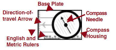
A compass has several basic parts (Figure 1).
- The compass needle, often red and black or red and white, always points toward the Earth’s magnetic north pole. This magnetic needle floats freely if the compass is held level (parallel to the ground).
- The compass housing has numbers, tick marks, and letters. The numbers run from 0 to 360, representing the number of degrees in a circle. The letters N, S, E, and W represent north, south, east, and west.
- The base plate has a direction-of-travel arrow. You point the direction-of-travel arrow in the direction you want to travel.
- Some compasses have inches or millimeters marked on the edge of the compass. These are used with a map scale to determine the distance between two points. This is not covered in this publication.
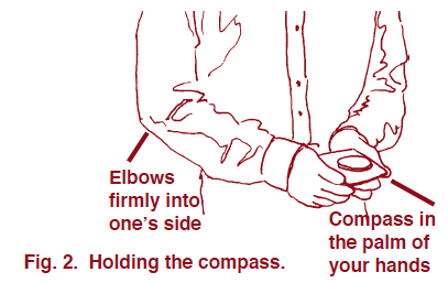
To use the compass (Figure 2), you need to hold it steady and keep it away from metal. Place the compass in the palm of one hand and place that hand in the palm of your other hand. Pull your elbows firmly into your side.
Since the compass needle is sensitive to metal, remove metal belt buckles, rings, and watches, and stay away from metal fences, automobiles, etc., to eliminate false readings.
While holding the compass level, point the direction-of-travel arrow in the direction you want to travel. Then turn the compass housing until the compass needle aligns with the arrow marks drawn on the bottom of the compass. Remember, the colored end of the compass needle points north. Now move so that you are looking straight ahead in the direction in which you want to travel. Be sure that the magnetic needle still points north.
To keep from straying too far to the left or right of direction-of-travel, pick an object as far away as possible to align with. Stop occasionally to make sure you are headed in the correct direction. Keep repeating this process to stay on course.
Pacing
Pacing is a simple method of measuring linear distance by walking. One pace equals two steps, beginning and ending on your dominant foot (Figure 3). To determine your pace, practice by walking repeatedly with a normal stride over a measured course. Pace the course several times to determine your average pace, and then use the pacing chart below to determine your distance per pace.
| Paces / 66 feet | Feet / pace | Paces / 66 feet | Feet / pace | Paces / 66 feet | Feet / pace | Paces / 66 feet | Feet / pace |
|---|---|---|---|---|---|---|---|
| 10.0 | 6.60 | 13.5 | 4.89 | 16.5 | 4.00 | 19.5 | 3.38 |
| 10.5 | 6.28 | 14.0 | 4.71 | 17.0 | 3.88 | 20.5 | 3.22 |
| 11.5 | 5.74 | 14.5 | 4.55 | 17.5 | 3.77 | 21.0 | 3.14 |
| 12.0 | 5.50 | 15.0 | 4.40 | 18.0 | 3.67 | 21.5 | 3.07 |
| 12.5 | 5.28 | 15.5 | 4.26 | 18.5 | 3.57 | 22.0 | 3.00 |
| 13.0 | 5.08 | 16.0 | 4.13 | 19.0 | 3.47 | 22.5 | 2.93 |
A common use of pacing in forestry is to measure tree height. This is discussed in Woodland Owner Note 5, Estimating the Volume of a Standing Tree Using a Scale (Biltmore) Stick. Listed below are the directions to determine your pace on a 66-foot course.
- Measure a 66-foot course, on level ground, with a tape measure. Use this course to determine the accuracy of your pace.
- Pace off this course three or four times. Compare the results. Make sure all are similar and the steps in each pace fit your stride.
- Using the pacing chart, determine how many linear feet each of your paces covers. For example, if it takes you 13 paces to cover 66 feet, then each of your paces is 5.08 feet.
- When walking from one point to another where you do not know the distance, pace the distance. Record the number of paces, and then multiply by the length of your pace. For example, if it takes you 20 paces to cover an unknown distance, multiply your known pace (say 5.08 feet) by 20 paces to get 101.6 feet.
On level, open ground, pacing can be fairly accurate with practice. But on slopes and in brushy or rocky areas, its accuracy diminishes. In difficult terrain, do not try to maintain your standard pace. Instead, allow for the inevitable shortening of your pace (downhill as well as uphill) by repeating the count at intervals. For example, on moderate slopes, count every tenth pace twice: 1,…,9, 10, 10, 11. On steeper slopes, it may be necessary to repeat every fifth count: 1,…,4, 5, 5, 6. On the steepest slopes, in very heavy brush, in swamps, or among boulders, every count may have to be repeated. Consistent accuracy in pacing under such conditions is attained only by practice and is maintained only by constant checking.
If you practice using a compass and take the time to determine your pace, you will find traveling through the woods is much easier. Remember, in order to use a compass and pace successfully, you need to practice.
Publication date: Jan. 1, 2007
Reviewed/Revised: Feb. 29, 2024
WON-39
N.C. Cooperative Extension prohibits discrimination and harassment regardless of age, color, disability, family and marital status, gender identity, national origin, political beliefs, race, religion, sex (including pregnancy), sexual orientation and veteran status.


