
This publication discusses how zoning and land use regulations impact the practice of forestry in North Carolina. This publication also explains planning jurisdictions, components of a zoning ordinance, and where to go for more information.
Forest landowners and others involved with forest management practices need to know about county and municipal jurisdictions and the land use laws and regulations that apply to their forestlands. Local land use regulations can impact forest harvesting, thinning, and replanting. Forest landowners may have to bear the burden of substantial fines, legal costs, restoration costs, and other expenses if zoning and other land use regulations are violated. To avoid fines and penalties, landowners must know which land use regulations apply to their property.
Common Land Use Regulations
Land use regulations set limits on what can be done on your land. Regulations are enacted and enforced by local governments—counties and municipalities—to protect the public health, safety, and welfare of citizens. Regulations seek to protect community aesthetics and property values, and to promote the highest and best uses of property. Common ordinances that regulate land use include:
- Zoning
- Landscaping
- Water supply watershed protection
- Sediment and erosion control
- Floodplain and floodway
Many of these ordinances commonly provide exemptions for forestry practices when specific requirements are met.
Zoning is the most common form of land use regulation used by local governments in North Carolina. Zoning typically contains landscaping requirements or other provisions that depend upon the type of land use regulated. Landscape requirements and provisions can be used to protect community trees and vegetation, and to separate and shield different uses on adjoining properties. The county or municipal planning jurisdiction that your land is located within will determine the type of zoning or other land use regulations that may be applied.
Are Your Activities Considered Forestry?
Using your land for forestry involves harvesting, thinning, and other practices conducted under a sound forest management plan. The cutting of trees alone may not be considered forestry, or silviculture, by many local governments. Certain jurisdictions exempt forestry from their zoning and other land use regulations. Exemptions typically require the property to be under an active forest management plan, enrolled in the present-use-value taxation program, and that forestry best management practices are employed when conducting forestry activities.
Planning Jurisdictions
A planning jurisdiction is the total geographical area over which a local government has authority over land uses. Many types of land use regulations, including zoning, may be enforced in the planning jurisdiction.
County planning jurisdiction applies to all areas of a county that are not within the corporate boundaries (city or town limits) of a municipality or its planning jurisdiction. Land not within the county jurisdiction is within a municipality’s planning jurisdiction. Occasionally, a municipality and a county form an agreement to enforce land use regulations in the other’s jurisdiction. Both counties and cities (N.C.G.S. §§ 160D-200 et seq.) can pass ordinances to regulate use and development of land as authorized by the North Carolina General Statutes.
Municipal planning jurisdiction may consist of two areas:
- the city’s or town's corporate boundaries; and
- the city’s or town's extraterritorial jurisdiction.
A municipality's corporate boundaries consist of its primary city limits and noncontiguous areas called satellite annexations. Your forestland could be entirely in a county’s planning jurisdiction, entirely in a municipality’s jurisdiction, or partly within a county and a municipality’s planning jurisdiction (Figure 1). Also, a city’s corporate boundaries and planning jurisdiction may exist across more than one county. For example, the city of Rocky Mount lies in both Nash and Edgecombe counties.
County and municipal ordinances vary widely across jurisdictions in text, interpretation, and enforcement. Always confer with local officials when in doubt.
Planning jurisdiction boundaries can change
A county planning jurisdiction may not be expanded unless the county forms an agreement with a municipality that allows the county to enforce land use regulations within the town’s planning jurisdiction. A city or town also can request a county to enforce other ordinances, such as noise ordinances, within the municipal planning jurisdiction. A municipality, however, can create and expand its planning jurisdiction in any of three ways:
- Incorporation is the creation of a new town. Area included within the corporate boundaries is part of the town and subject to zoning and other regulations.
- Annexation occurs when a city or town expands its boundaries to make an area part of its corporate boundaries (city limits). All existing municipal laws and regulations apply to the annexed area. There are statutory limitations on the annexation of property used for bona fide farm purposes.
- Establishment of an extraterritorial jurisdiction (ETJ) occurs when a city or town adds an unincorporated area to its planning jurisdiction. The municipality can enforce only regulations related to land use and development in an ETJ.
Many landowners may not realize they are within an ETJ—and as a result may receive fines or warnings for land use activities they conduct on their land that do not comply with municipal zoning or other ordinances. Planning jurisdiction boundaries change frequently as areas are annexed and ETJs are created. Check these boundaries periodically to ensure that you know which jurisdiction applies to your land. This information should be included and updated in your forest management plan.
Extraterritorial jurisdiction
An ETJ is established by adding an unincorporated area (outside of the corporate boundary) to the municipal planning jurisdiction. The ETJ must be connected to the primary corporate boundary and cannot be drawn from a satellite annexation. An area within an ETJ may eventually be annexed and become part of that municipality. All towns or cities may establish an ETJ within one mile of the town or city boundaries (N.C.G.S. § 160 D-202). In addition, cities ranging in population from 10,000 to 24,999 can establish an ETJ within two miles of their municipal boundary. Cities with populations of 25,000 or more can establish an ETJ not more than three miles beyond its municipal boundary. Approval from the board of county commissioners is required if an ETJ is proposed in an area where the county is already exercising its zoning and subdivision authority and enforcing the State Building Code. All cities may enforce public health and safety regulations (nuisance abatement, burning, or noise ordinances) within one mile of their corporate boundaries without establishing an ETJ.
Municipal land use regulations typically take precedence over county land use regulations within an ETJ. The city may exercise exactly the same land use regulation authority within the ETJ as it does in the primary city limits, but it may choose not to enforce an ordinance that it is already enforcing in the corporate boundaries. Cities may regulate land uses within ETJs through zoning, soil erosion and sedimentation control, floodway development, watershed protection, landscaping and community appearance ordinances, and other ordinances adopted pursuant to their planning and zoning authority. However, under N.C.G.S. § 160 D-903(c), property used for bona fide farm purposes—including some forestry activities—is exempt from the city's zoning regulation to the same extent bona fide farming activities are exempt from county zoning. Counties retain authority to enforce ordinances created pursuant to their general ordinance-making authority in the ETJ, such as nuisance ordinances.
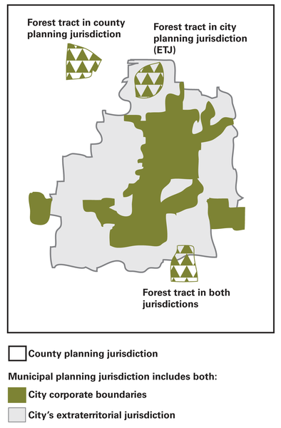
Figure 1. Forestland subject to county and municipal planning jurisdictions
Zoning
Zoning prevents conflicts between various land uses (for example, by not allowing a noisy sawmill to operate next to a hospital). Counties can enforce zoning in a portion of the county or throughout the entire county. Almost all municipalities in this state have zoning. Unlike counties, however, they must enforce zoning throughout their entire planning jurisdiction. Zoning regulations must be created, amended, and enforced in accordance with a municipality’s or county’s comprehensive plan.
Check before Proceeding with Forestry Activity
Uncertain of zoning or other land use regulations that apply to your property? Check with the local government that has jurisdiction over your property before proceeding with your forestry activity. Inquire if exemptions exist for forestry, and ask if your activity qualifies for those exemptions before proceeding.
Zoning districts and maps
Zoning defines uses and creates various zones or districts within part or all of a county’s and all of a municipality’s planning jurisdiction. Zoning identifies allowable uses and may prohibit other uses that are not specified in that ordinance. However, provisions can be written into the ordinance that allow landowners to obtain conditional or special use permits to conduct uses not already allowed in a zoning district. Zoning ordinances may also be amended to add zoning districts and additional defined and permitted uses.
Zoning districts established in the ordinance text are shown on a zoning map. Abbreviations are assigned to these districts for simplicity, but they can differ in meaning across local governments. For example, RA-20 may mean “Residential-Agricultural: 1 unit (house) per 20,000 square feet” in one community, but it may mean “Rural-Agricultural: 1 unit per 20 acres” in another jurisdiction. The zoning text will list the abbreviations for each named district.
Districts may be classified as conventional use or conditional use (special use) districts. In a conventional district, a use such as forestry may be allowed without having to obtain a permit. In a conditional use district, a permit may be required before you can conduct forestry activities. Be aware of overlay districts, which may be applied over the underlying zoning district, as they can add additional restrictions or conditions to land use across multiple districts.
Zoning and forestry
If your forestland is zoned, the following restrictions and provisions may apply:
- Forestry is exempt.
- Forestry is permitted.
- Harvest is constrained.
- Harvest of certain trees is constrained.
- Tree harvest location is constrained.
- Replanting and maintenance of trees following removal is required.
Land use regulations, including the zoning ordinance itself, may be contained within a unified development ordinance (UDO). Landscaping requirements, such as buffers of different widths and types of vegetation, may apply to your property depending on the zoning district in which your property is located. If forestry is not defined and listed as a permitted use in the zoning ordinance, it may not be allowed without further interpretation from the local government enforcing the ordinance. Forestry activities may be regulated similarly to other aesthetics issues such as overgrown and weedy lots or the pruning and topping of trees.
Forestry is considered a bona fide farm purpose exempt from county zoning under state law because zoning does not apply to the planting and production of trees and timber (N.C.G.S. § 160D-903(a) referencing N.C.G.S. § 106-581.1). Municipalities are not required to exempt bona fide farm purposes, such as forestry, from zoning in their corporate boundaries, although a few North Carolina municipalities do provide exemptions. For more information on exemptions and flexibility for forestry and farming within local land use regulations, refer to Woodland Owners Note 41, Practicing Forestry under Local Regulations.
Zoning ordinance components
Zoning ordinances typically consists of three components:
- The zoning text establishes and describes the purpose of zoning districts, defines uses, and lists allowed or restricted uses within a zoning district (see “Examples of Zoning Text” boxes).
- A table of permitted uses lists the zoning districts and the possible allowed uses (Table 1).
- A zoning map identifies the districts where forestry activities are allowed (Figure 2).
Is Forestry an Allowable Use?
To determine if forestry is an allowable use within your municipal or county planning jurisdiction, review the zoning ordinance that applies to your property. Be sure to review each ordinance component:
1. Identify the jurisdictions that apply to your property
If your forestland falls within a planning jurisdiction that applies zoning, you must determine if forestry is an allowable use. If your forestland is in a municipality’s planning jurisdiction, its zoning may apply to your land. Otherwise, your land falls under the county planning jurisdiction and county zoning may apply to your land. A possible exception to this situation is if a local government has an agreement to enforce land use regulations within another local government’s planning jurisdiction.
Examples of Zoning Text that Defines the Zoning Districts
4.2.2(A) R-80: Residential District
The R-80 district is established to ensure the protection of open space and to promote very low-density residential development that is compatible with watersheds and other environmentally sensitive areas, subject to appropriate standards. The district also can serve as an appropriate buffer between natural resources and water supply reservoirs and more developed areas. The minimum lot area is 80,000 square feet, and the maximum density allowed is 0.54 units per acre.
4.2.2(B) R-40: Residential District
The R-40 district is established to accommodate large-lot residential uses and development compatible with the natural landscape. The minimum lot area is 40,000 square feet, and the maximum density allowed is 1.08 units per acre. The R-40 district can accommodate development on wells and/or septic tanks; but lots within new subdivisions in this district are required to connect to public water and sewer.
4.2.2(C) R-20: Residential District
The R-20 district is established as a district in which the principal use of land is for low-density residential purposes. All development in the R-20 district shall be required to utilize public utilities. The minimum lot area is 20,000 square feet, and the maximum density allowed is 2.17 units per acre.
Examples of Zoning Text that Defines Forestry
12.3.4 Commercial Uses
12.3.4(A) Agricultural Uses
Activities that primarily involve raising, producing, or keeping plants or animals, or cultivation and management of other natural resources. Accessory uses may include dwellings for proprietors and employees, barns, storage of grain, animal raising, feed preparation, and wholesale sales of products produced on-site. Specific use types include:
- Agri-Tourism
An area of land used for the purpose of education and participation in an agricultural related business operation. - Farming, general
An area of land used for the commercial production of agricultural products such as crops, dairy products, livestock, and poultry. - Forestry
The science, business, and art of creating, conserving, and managing forests or forestlands for the continuing uses of commodity and noncommodity benefits. - Produce stand
A structure and/or area devoted to the small-scale retail and/or wholesale sales of agricultural goods or products that have been grown on the same site or property as the stand.
Example of Zoning Text Listing Allowed Uses
Sec. 18-177. R-20, Residential District
(a) Purpose.
The R-20, Residential District, is established as a residential district in which the principal use of land is for low-density residential and recreational purposes. The regulations of this district are intended to discourage any use that because of its character would substantially interfere with the development of residences and that would be detrimental to the quiet residential nature of the areas included within the district.
(b) Uses Permitted by Right.
The following uses are permitted by right in the R-20 district, provided that they meet all requirements of this section, Article 6, and all other applicable requirements established in these regulations:
- Single-family, detached
- Family care home
- Golf courses, private or public, with related services, including pro-shop
- Parks and recreation areas, municipal
- Recreation facility, private
2. Check the zoning text
Review the zoning text to see if forestry is a defined use. It may be included with the terms “agriculture” or “farming.” Also, check to see if the activities on your land meet the definition of forestry in the ordinance. Forestry may also be referred to as “silviculture,” “timber harvesting,” or other similar terms within zoning ordinances. Some communities may not define forestry as a use in the zoning text though it may still be listed in the table of permitted uses (Table 1).
Table 1. Table of Permitted Uses — General Use Districts (Except TC and CT)
P = Permitted Use; S = Special Use; A = Accessory Use
Use class is listed for determining the type of required perimeter buffers.
| Use Category | Use Type (Use Class) | R80 | R40 | R20 | R12 | R8 | TR | RMF | RR | OI | GC | ORD | I | NC | GC | RC | Use Specific Standards |
|---|---|---|---|---|---|---|---|---|---|---|---|---|---|---|---|---|---|
| Farming, general (1) | P | P | P | ||||||||||||||
| Forestry (1) | P | P | |||||||||||||||
| Produce Stand (1) | P | P | 5.2.3(C) | ||||||||||||||
| Animal Service | Kennel, indoor only (4) | S | S | P | P | P | P | P | P | P | 5.2.3(E) | ||||||
| Kennel, indoor/outdoor (6) | S | S | S | S | P | P | 5.2.3(E) | ||||||||||
| Veterinary hospital/office, with indoor kennel (4) | P | P | P | P | P | P | P | 5.2.3(O) |
3. Check the table of permitted uses
Is forestry included as a possible allowed use? Allowed uses are denoted by a letter symbol in the table where a listed use intersects with a zoning district; non-permitted uses are left blank. Symbols used to denote allowed uses are defined in the text or on the table. For example, in Figure 5 the letter “P” indicates that a use is permitted as of right and the letter “S” signifies a special or conditional use. A use that is “as of right” may be allowed in a district without the need for a permit or permission from a local government. A conditional or special use is one where a permit must be obtained prior to the use being conducted. If forestry is not listed in the table of permitted uses, or is not a defined or listed use in the zoning text, contact your local planning and zoning department to find out how forestry may be added as a defined use to the zoning ordinance.
4. Check the zoning map
Identify the districts where forestry activities are allowed. The zoning map shown in Figure 2 shows the location of R40 and R20 zoning districts that allow forestry. If a zoning map shows that your property is in a district that does not allow forestry, contact your local planning and zoning department for information on seeking a conditional use permit or having the zoning changed for that district.
5. Obtain information on jurisdictions and land use regulations
County and city planning, zoning, environmental, engineering, and inspection departments can provide information on the planning jurisdictions that apply to your land. These departments can explain the ordinances and land use regulations you must follow when engaging in forestry practices on property in their planning jurisdictions. Zoning and other land use regulations are maintained by counties and cities at courthouses, offices of county and city clerks, and often in departments responsible for enforcement. Regulations and guidance materials are also available on the internet through legal databases and local government websites. However, it is best to check with local authorities to ensure you are accessing the most up-to-date regulation.
City and county attorneys and managers are good sources of regulatory information. Forest landowners, and their consulting foresters, need to be mindful that local officials and city and county attorneys represent their respective local governments. If forest landowners need a second opinion with regards to guidance or interpretation of a local regulation, they may seek the advice of other local officials or outside legal counsel. Retain all guidance on, and interpretations of, land use regulations in writing for future reference.
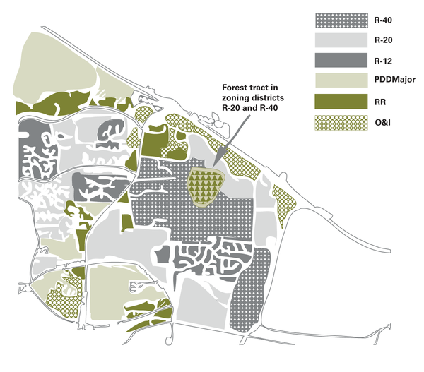
Figure 2. Example of a portion of a zoning map based on the permitted uses in Table 1.
Caution
Landowners should never attempt to engage in forestry practices based solely on what they read in the county or municipal code or on a local government’s website. Always rely on the combined guidance and interpretation from the local officials responsible for enforcing ordinances and regulations and guidance from an attorney.
The failure of a county or municipal official to provide you with the most recent amendments to an ordinance or rule does not relieve you of the obligation to comply, nor does it result in the imposition of liability upon that official or that official’s employer.
No forestry practices should be conducted without first receiving interpretation and guidance about local land use regulations and how they may apply to your property. Your local planning and zoning department can give you guidance on what regulations may apply to your land. Contact and guidance information is often available on a local government’s planning, zoning, or environmental department websites
Figure 3 is designed to guide you through a zoning ordinance to determine if you can practice forestry on your land.
Step 1. Is your property covered by zoning? If yes, proceed to the next step. If no, check with your local government if additional regulations apply before proceeding.
Step 2. Does zoning constrain forestry activity? Under county jurisdiction, forestry may qualify as a bona fide farm use and may be exempt from zoning. Municipalities may exempt forestry from their zoning. If zoning does constrain forestry activity, proceed to the next step. If not, check with your local government if additional regulations apply before proceeding.
Step 3. Is forestry a permitted use listed in the zoning text, definitions, or table of permitted uses? Look at the zoning text to find the purposes of districts as a guide to where a use may be allowed. If forestry is a permitted use in the zoning text, proceed to the next step. If not, talk to your local zoning and planning department to see how forestry can be added as a use to the zoning ordinance before taking any further action.
Step 4. Find the districts on the zoning map where forestry is permitted. Does your land fall within those districts? Consider overlay and floating districts when reviewing the zoning map. If your land does fall within a district where forestry is permitted, proceed to the next step. If not, talk to your local zoning and planning department to see how forestry can be added as a use to the zoning ordinance before taking any further action.
Step 5. Forestry may be allowed as a permitted, conditional, or special use. Look at conditions that must be met and permits that may be needed to practice forestry in these districts. Tree clearing permits are required in some jurisdictions, even if forestry is allowed. Is a tree clearing permit required for your land? If not, check with your local government to see if additional regulations apply before proceeding further.
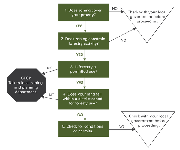
Figure 3. Determining if forestry can be practiced on your land
Other Resources
For more information on forestry management practices and local regulatory information, please review the following:
Publications
Practicing Forestry Under Local Regulations. WON-41. NC State Extension, North Carolina State University, Raleigh, NC.
Web sites
North Carolina State University Extension Forestry. NC State Extension, North Carolina State University, Raleigh, NC.
UNC School of Government. University of North Carolina, Chapel Hill, NC.
References
Lawrence, D. M., Wicker, W. J. 1996. Municipal Government in North Carolina. Chapel Hill, N.C.: Institute of Government, University of North Carolina.
Lovelady, A., Owens, D. W., and Hitchings, B. (n.d.). Chapter 160D: A new land use law for North Carolina. UNC School of Government. Retrieved November 19, 2021.
Owens, D., and N. Branscome. 2006, May. An Inventory of Local Government Land Use Ordinances in North Carolina. Special Series No. 21. Chapel Hill, NC: School of Government, University of North Carolina at Chapel Hill.
Owens, D. 2006, January. An Inventory of Local Government Land Use Ordinances in North Carolina. Special Series No. 20. Chapel Hill, NC: School of Government, University of North Carolina.
Owens, D.W. 2001. Introduction to Zoning. Chapel Hill, NC: Institute of Government, University of North Carolina.
Owens, D.W. 1999. Legislative Zoning Decisions: Legal Aspects. Chapel Hill, NC: Institute of Government, University of North Carolina.
Acknowledgments
The author acknowledges the following publication reviewers for their efforts:
Richard Ducker, Assoc. Professor of Public Law and Government, UNC School of Government
Ted Feitshans, Extension Specialist and Lecturer, NC State University
Christy Perrin, Program Coordinator, WECO, NC State University
Kurt Smith, Open Space Planner, Parks, Recreation, and Open Space, Wake County, NC
The author thanks Brandon A. King and Mark A. Megalos for their contributions to a previous version of this publication.
Publication date: March 11, 2022
WON-43
N.C. Cooperative Extension prohibits discrimination and harassment regardless of age, color, disability, family and marital status, gender identity, national origin, political beliefs, race, religion, sex (including pregnancy), sexual orientation and veteran status.
